Water & Drought
Water

Saskatchewan's environment, ecology and economy are water dependent and so are strongly impacted by hydrological cycling and water supply fluctuations. We have extensive periods of water shortage and excess, a strong seasonality in surface water supply and a cool semi-arid to cold sub-humid climate. In southern Saskatchewan, many of our ecological and economic activities use close to or all available water and so we are particularly vulnerable to further variations in water resources due to climate change.
Hydrology and the use of water in Saskatchewan
- Southern Saskatchewan's hydrology is characterized by:
- Low precipitation which mostly evaporates, leaving little for runoff
- Snowmelt is the primary source for the North and South Saskatchewan Rivers and also for the streams and rivers that arise in Saskatchewan.
- Local-scale water resources are very sensitive to changes in climate and land cover.
- The most reliable water supply comes from groundwater and rivers that originate in the Rocky Mountains.
- Most of Saskatchewan's water use is in the south, while most of the water is in the north.
- Urban demand for secure, high quality water is growing. Cities and towns produce waste water that must be treated.
- Drought in the south has shown that many local surface water supplies are unreliable and alternatives are being increasingly explored.
- The major water resource of the south is the South Saskatchewan River. It has been substantially developed as a water resource. Use is split among agriculture (86%), municipal (9%), thermal electricity (3%) and industrial use (2%).
Drought
The Prairie Provinces have experienced deep and multi-year droughts (Figure 1). This is based on instrumental records of Prairies climate over the past 120 years or so and on research based on tree ring analysis across many Prairies sites. It is sobering to see that the Prairies have experienced frequent and much more severe droughts in the past than the 1930s experience. At one point during a drought of the 1700s, we know from fur trader records that the North Saskatchewan River (at Edmonton) actually ran dry!
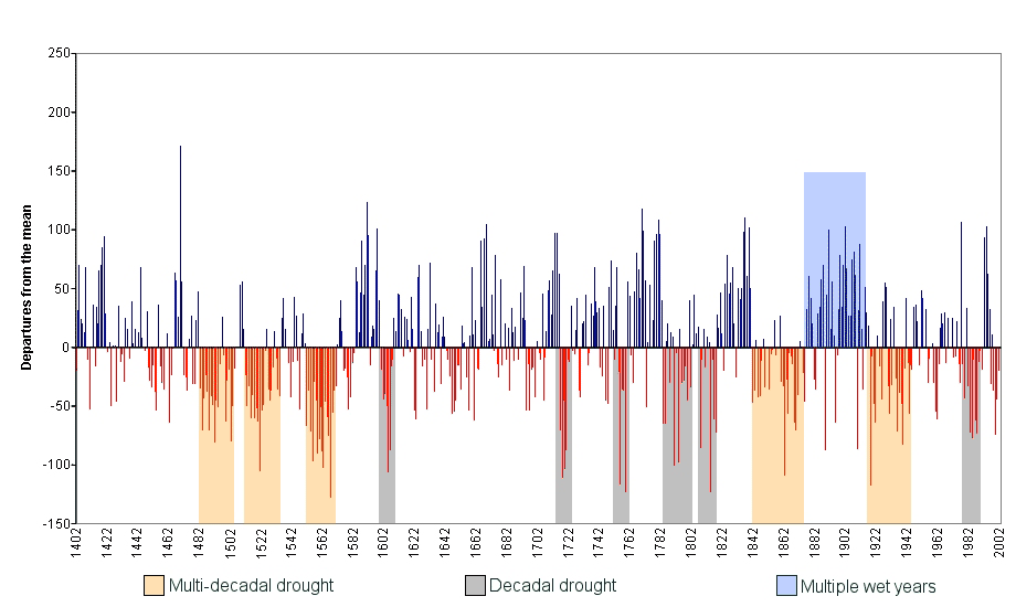
Figure 1: Drought Frequency and Severity for the Prairie Provinces (1402 to 2002)
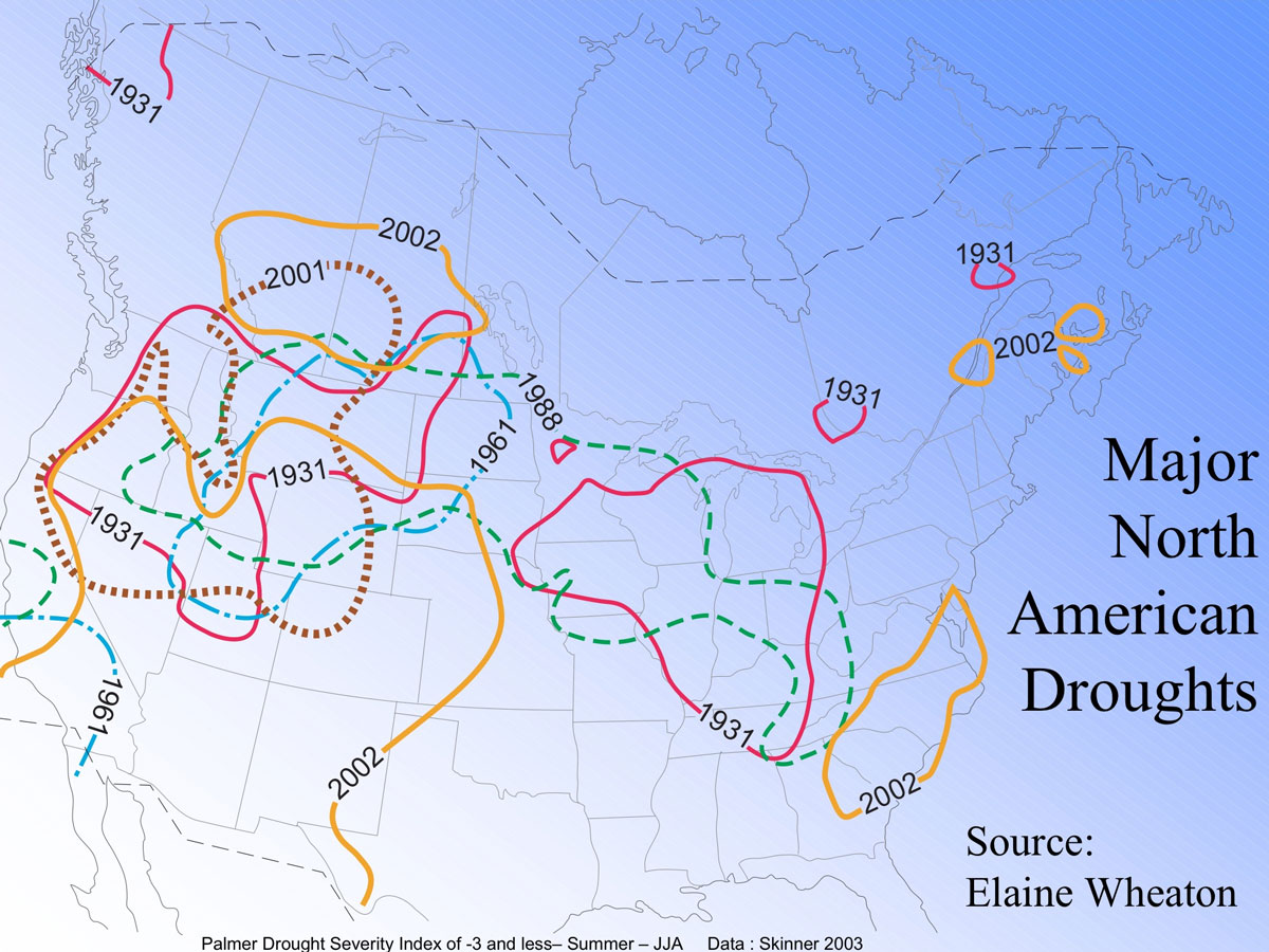
Drought has accounted for the greatest natural disasters in Canadian experience (in terms of economic cost). This includes drought on the Prairies in the 1930s and the recent drought of 1999-2004 (Figure 2). The impacts of the drought, largely occurring in Saskatchewan, during 2001-2002, was a national loss of $6 billion in GDP and the disappearance of 41,000 jobs.
Key Climate Change Factors:
- Winter warming will reduce snow accumulations across the Prairies.
- Water flows in the North and South Saskatchewan rivers entering Saskatchewan may decline over time.
- Water shortages already apparent in many areas of the province in drought years may become more serious.
- Global climate scenarios suggest that we will experience deeper and longer droughts in the future.
- Average annual moisture balances are expected to decline
- More variability is expected.
- Expect some very wet years within the trend towards drier conditions.
- Expect drier soils result in decreased subsurface recharge, which will lead to a decline in the water table in many regions.
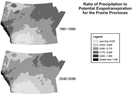
The following map (Figure 3) shows one projection of the increasing aridity within the Prairie Provinces by the 2050s, as compared to 1961-1990. Areas indicated at less than 0.650 can be considered at risk of persistent drought and, if mismanaged, desertification.
Impacts - Streamflow Changes:
Expect
- declines in annual streamflow
- shift in timing to earlier in the year
- lower summer water supplies
- continued glacier retreat in the Rocky Mountains
Streamflows under Climate Change
- Modelling for the South Saskatchewan River yields:
- An average decrease of 8.5% in river flow at the Saskatchewan-Alberta border
- Hydrological models for prairie streams suggest:
- a 24% increase in spring runoff by 2050 and
- a 37% decrease by 2080 as the winter snowcover becomes discontinuous.
- As climate change progresses there will be drops in runoff and in the flow of small streams to wetlands and depressions and to small prairie rivers.
- The longer summers and longer periods of evapotranspiration will result in drier soils for more days in summer. Water needs for agriculture will likely increase and so pressure for irrigation of farmland using river water will increase.
- There is potential for increased year-to-year variability, for example, more drought years, but also the occasional flood year.
Impacts of Drought:
- On the taiga and boreal forest ecozones:
- declining soil moisture
- increased forest fire extent.
- likelihood of flash floods will increase as organic soils are burned along with forests, resulting in a total loss of vegetation and soil cover.
- possible reductions in forest productivity
- On native prairie and agricultural land:
- change in grassland species composition
- enhanced soil erosion
- increased sand dune activity
- slopes and stream channels exposed to less frequent but more intense rainfall will also be vulnerable to increased erosion and shallow slope failures
- erosion will increase stream sediment and nutrient loads in local water systems
- eutrophication of water bodies and increased pathogen loading in streams during the summer
Adaptation Options:
- Investigate opportunities for developing new infrastructure for increased storage of water.
- Develop and enhance water conservation research and programming.
- Work with communities to manage water efficiently.
- Carefully examine water pricing and allocation systems to ensure water is not wasted.
- Protect surface and groundwater from pollution.
- Carefully consider the advisability and sustainability of any future irrigation projects.
- Saskatchewan should evaluate its plans for increased irrigation very carefully in light of reduced water availability from Alberta due to increased consumption and climate change. But more efficient water use for irrigation or a reduction in irrigated acreage in Alberta could compensate for the reduced water availability.
- Develop new crop varieties and tillage methods.
- Drainage of wetlands may have to be reversed to buffer wetland, lake and reservoir levels.
- Integrated basin management of the South Saskatchewan River across both Alberta and Saskatchewan and for smaller watersheds in Saskatchewan is the best adaptation method for dealing with climate uncertainties. Integrated basin management plans with apportionment powers, enforceable land use controls and agricultural management incentives may need to be implemented to deal with changes and increased uncertainties in water management and supply.
Adapting to Drought
Both groundwater and surface water supplies can deteriorate in severe droughts. In Saskatchewan, about 45% of the population relies on groundwater as a source of drinking water. There are a number of things we can do as individuals and as a Province to increase our ability to cope with drought:
- As an individual, consider how exposed you are to drought risk, and how you would cope with a severe drought. You may want to reduce water usage in the home and yard, for example.
- Farms, towns and cities need to consider the volume and quantity of water available to them during a drought. In some cases, better supply access may need to be secured.
- Farmers and ranchers need plans and management to cope with drought, while forest managers need to be able to handle high fire risk seasons.
- We need to avoid wasting water, charge appropriately for water use, and ensure water gets to the appropriate user. In some cases, minimum natural water flows will be needed to protect aquatic systems.
Sources:
- Demuth, M.N. and Pietroniro, A. (2003): The Impact of Climate Change on the Glaciers of the Canadian Rocky Mountain Eastern Slopes and Implications for Water Resource-related Adaptation in the Canadian Prairies; Prairie Adaptation Research Collaborative, Regina, Saskatchewan, Project P55, 111 p.
- Martz, L., Bruneau, J., and Rolfe, J. (editors) (2007): Climate Change and Water: South Saskatchewan River Basin Final Technical Report, 252 p.
- Sauchyn, D. et al (2009): Saskatchewan's Natural Capital in a Changing Climate: An Assessment of Impacts and Adaptation. PARC, 162 p.
- Sauchyn, D.J. and Kulshreshtha, S. (2008): Prairies; in From Impacts to Adaptation: Canada in a Changing Climate 2007, (eds.) D.S. Lemmen, F.J. Warren, J. Lacroix, and E. Bush; Government of Canada, Ottawa, Ontario, p. 275-328.
- Sauchyn, D.J., Stroich, J. and Beriault, A. (2003): A Paleoclimatic Context for the Drought of 1999-2001 in the Northern Great Plains; The Geographical Journal, v. 169, no. 2, p. 158-167.
- Wheaton, E., (2004?): Major North American Droughts (Map), Saskatchewan Research Council. From Sauchyn, D. (2004): A 330-year Climate and Human History of Prairie Drought (Presentation to Canadian Prairies Drought Workshop - Science, Monitoring and Prediction, Calgary, May 27-28, 2004) PARC