Saskatchewan's Climate: Current
A Continental Climate - Extreme Temperatures and Low Precipitation
Saskatchewan has a continental climate, experiencing extremes in temperature and weather events, relatively low precipitation which falls mostly during summer months, and considerable sunshine.
Saskatchewan is located in the centre of the continent - far from any moderating oceanic influences. As a result the temperature is primarily determined by the heat energy radiating from the sun. In addition, a variety of air masses and wind regimes bring with it diverse weather experiences. Temperatures can range from -40°C in the dead of a northern winter to +35°C during summer in the southern regions.
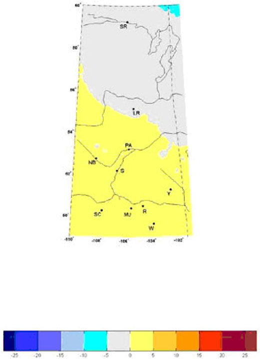
The extreme nature of the climate extends to severe climate events as well: from drought to flooding downpours, thunderstorms to blizzards and calm to tornadoes. Saskatchewan has one of the world's most variable climates across seasons, years and decades. There is a large difference in mean temperature and precipitation between the southwest and northeast corners of the province (Figure 1 and Figure 2). Generally, mean annual temperatures drop from south to north and from west to east within the province. Conversely, precipitation levels ordinarily increase from south to north. So what we find, in general, are warmer, drier conditions in the southwest and cooler moister conditions in the northeast.
The following communities are noted on both maps: SR-Stony Rapids, LR-La Ronge, PA-Prince Albert, NB-North Battleford, S-Saskatoon, Y-Yorkton, SC-Swift Current, MJ-Joose Jaw, R-Regina, W-Weyburn
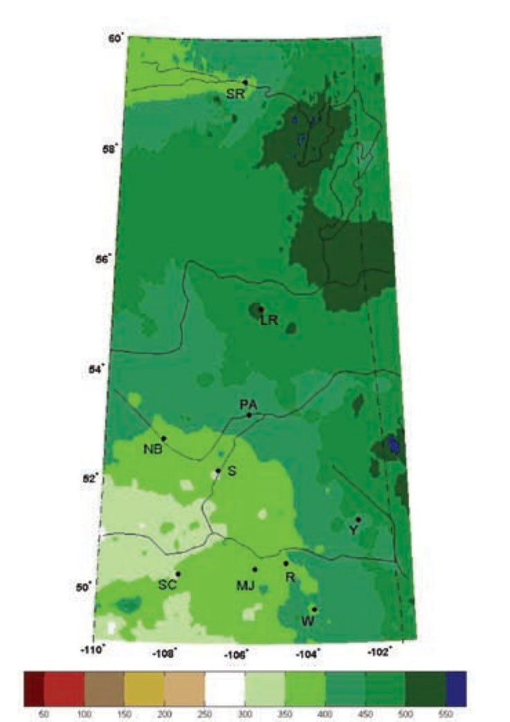
Evapotranspiration (evaporation and plant transpiration) is an important process influencing vegetation cover and soil moisture levels. In southern Saskatchewan precipitation mostly evaporates leaving little for runoff. Local snows feed our local streams, while the North and South Saskatchewan Rivers are largely fed by mountain snowmelt.
Saskatchewan's Ecological Framework - A reflection of climate variation
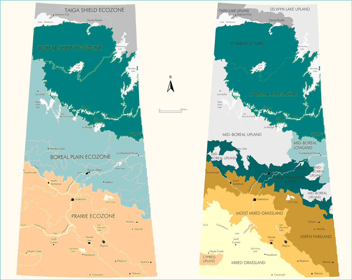
Saskatchewan has been divided into four ecozones (Figure 3a), which are further subdivided into ecoregions (Figure 3b) - or areas of similar soils and landscape. The ecological framework shows a similar trend as climate.
Each ecoregion differs in local vegetation, soils, water and local human activity. The boundaries of these ecoregions loosely align with areas of different climatic conditions and are therefore useful in assessing the impacts of climate change.
Temperatures are generally warmer throughout the year in the Prairie ecoregions than in the Boreal ecoregions. The same distinction exists between the Boreal ecoregions and the Taiga ecoregions.
Annual precipitation varies even more than temperature. Precipitation levels and variability tend to decrease from north to south. Annual precipitation is lower by 200 mm between the Taiga and the Prairie Ecozones zones. Across Saskatchewan summer brings the greatest percentage of annual precipitation.
Climate Normals for Specific Locations
Saskatchewan's current climate normals or averages are based on data collected by Environment Canada over a 30-year period from 1971 - 2000. Data is also available for the period 1961 - 1990. This latter dataset is often used in climate change research as a base, or reference climate.
Climate data is available for each weather station from the National Climate Data and Information Archive. A portion of the climate normals for Prince Albert is presented below (Figure 4) to illustrate some of the information available for each location and to provide you with a link to the original dataset.
The climate normal information available is summarized by month and includes measures based on:
- temperature
- precipitation
- wind
- pressure
- sunshine
- humidity
Dependent on the nature of your interest or business, this information can help illustrate its relationship to your local weather and climate and is a basis for determining how climate change might impact you in the future.
Example of Available Climate Data - Prince Albert, Saskatchewan
(click on this figure to go to the Environment Canada National Climate Data and Information Archive -- external website![]() )
)

Next Page › Saskatchewan's PAST Climate
Sources:
- Barrow, E. (2009a): Climate Scenarios for Saskatchewan. PARC, 131 p.
- Canadian Plains Research Centre (2005): Encyclopedia of Saskatchewan, Ecozones and Ecoregions.
- Environment Canada (2010): National Climate Data and Information Archive, Canadian Climate Normals website; station ID: 3322, Prince Albert
- Sauchyn, D. et al (2009): Saskatchewan's Natural Capital in a Changing Climate: An Assessment of Impacts and Adaptation. 162 pp. PARC