Thunderstorms, Heavy Rainfall & Flooding
Summers on the prairies are memorable for their dry, warm sunny days. Rainfall is often short-lived and welcomed. However, thunderstorms are relatively common and can result in significant precipitation falling over a short period of time accompanied by hail and lightning (Figure1). Storms can be accompanied with strong frontal winds called plough winds. As the climate warms and there is more energy and moisture in the atmosphere, precipitation is expected to increase and summer rainstorms are projected to be more frequent and intense.

Flooding and excess moisture usually arise from major thunderstorms, rain showers or high spring runoff. Adaptation to major rain showers and flooding is a challenge for urban and rural communities, including First Nations, and agriculture.
Thunderstorms
Thunderstorms are most prevalent in southern Saskatchewan, particularly in the southeast – Estevan, Whitewood and Yorkton (Figure 2). Frequency of lightning strikes is also highest in the southeast. Lightning strikes are virtually absent from the northeastern portion of the province (Figure 3).
-
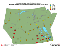 Figure 2: Thunderstorm Frequency
-
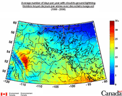 Figure 3: Lightning Frequency

Extreme daily rainfall amounts for selected sites are shown in Figure 4. As expected, the highest amounts are found in areas where thunderstorms are more common. The Canadian record for most intense rainfall recorded in an hour was set in 1963 in southern Saskatchewan at the hamlet of Buffalo Gap (near Coronach). A total of 254 mm of rain fell in an hour.

When high amounts of rainfall are experienced within a season or over the course of a year, there are significant impacts associated with excess moisture. Excessive ground moisture can cause water to migrate to low areas, refilling sloughs and dugouts but also flooding basements. With more rainfall, instead of infiltrating the soil the water runs off the surface possibly causing erosion and pollution. Agriculture in particular can be affected, resulting in seeding or harvesting being delayed. An early blanket of snow can delay freezing of the ground, thus restricting access to fields. A wet summer and fall, followed by excessive snowfall can lead to spring flooding. This was the situation in Saskatchewan in 2010-2011 (Figure 5 and 6).
-
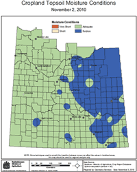 Figure 5: Surplus Moisture Conditions in Eastern Saskatchewan, November, 2010. (from SWA | Preliminary Runoff Outlook for Saskatchewan: Cropland Topsoil Moisture Conditions)
 -
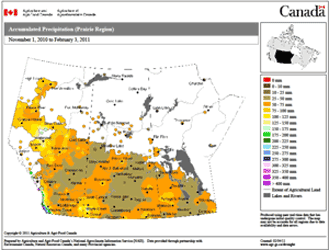 Figure 6: Major Snow Accumulation Across Southern Saskatchewan for the 3 month period between November 1, 2010 and February 3, 2011 (from SWA | Preliminary Runoff Outlook for Saskatchewan: Accumulated Winter Precipitation Map).


Flooding
Storms associated with high rainfall can lead to significant flooding issues particularly within communities. Nineteen flood events are identified within the Canadian Disaster Database for Saskatchewan. Some of the more noteworthy floods are directly related to high, intense rainfall events: 2010-Maple Creek, 2005-Cumberland House, 2000–Vanguard and 1975-Regina. Two additional flood events are attributed to high spring runoff: 1969-Qu’Appelle River and 1952-Eastend. The rainstorm and associated flooding of Maple Creek in 2010, occurred between June 14 and June 18, when over 100mm of rain fell over southwestern Saskatchewan. This led to flooding of the town (Figure 7) and a washout of the TransCanada Highway immediately to the north and west of town (Figure 8). Yorkton received 125mm on July 1, 2010 which resulted in major flooding that affected about 20 percent of the homes.
-
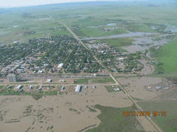 Figure 7: Flooding of Maple Creek; June, 2010 (Photo courtesy Saskatchewan Watershed Authority)
 -
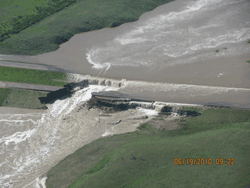 Figure 8: Flooding Near Maple Creek and Washout of Trans-Canada Highway; June 2010 (Photo courtesy Saskatchewan Watershed Authority)


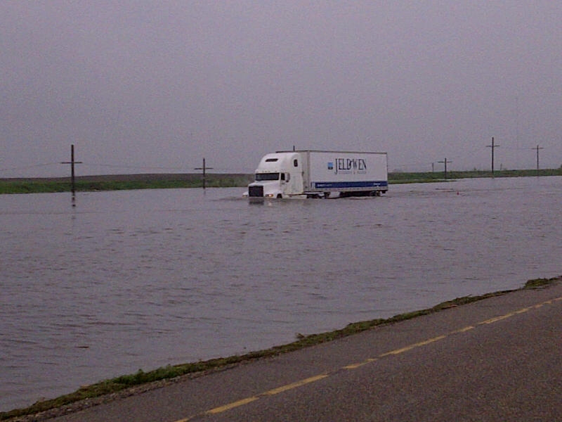
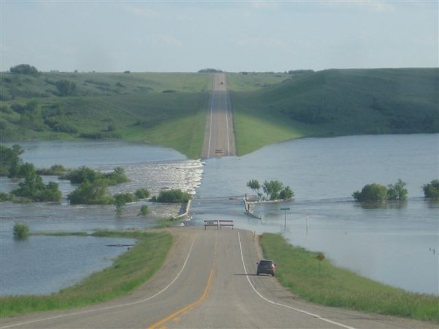
The spring and early summer of 2011 proved to have severe flooding, with many Saskatchewan communities experiencing flooding that ranged from light to severe. As well, sections of the Trans-Canada Highway (#1) were again forced to close. Figure 9 shows the west-bound lane of #1, near Wolseley, SK being totally submerged and only passable by large transport trucks. Figure 10 shows Highway 9 between Highway 18 and the Canada-US border on June 22, 2011. Visit the Saskatchewan Highways and Infrastructure website to view a photo gallery of flood event impacts on Saskatchewan roads from 2011.
-
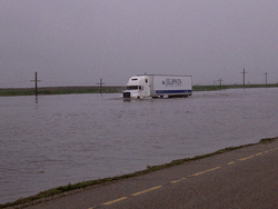 Figure 9: Trans-Canada Highway in the Wolseley area on June 20, 2011(Photo courtesy Saskatchewan Highways and Infrastructure)
 -
 Figure 10: Highway 9 between Highway 18 and the Canada-US border on June 22, 2011;(Photo courtesy Saskatchewan Highways and Infrastructure)
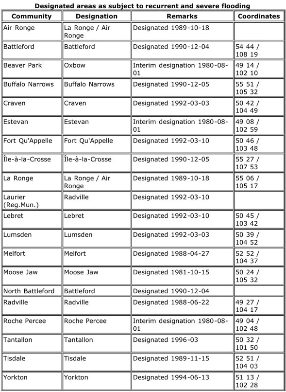
The federal government has operated a provincially cost-shared Flood Damage Reduction program (FDRP) since 1975. The program’s focus is to prohibit development within flood risk areas and support flood forecasting and the construction of infrastructure such as dykes. Saskatchewan communities that have had their flood risk areas identified are listed in Table 1.
Adaptation Actions
Adaptation for major rainstorms and thunderstorms will generally focus on reducing the property damage arising from high winds, soil erosion, flooding and excessive moisture issues. Adaptation requires action by communities, farmers and property owners.
- Improve forecasting and become familiar with forecasting information available via the media and on the internet – weather radar and lightning detectors.
- Prepare for power outages.
- Insure against the risk where warranted and cost effective.
- Continue with emergency management and disaster assistance program (see SaskAdapt.ca Success Story – Natural Disaster Response)
Communities:
- Prohibit development in low-lying areas through zoning and/or help homeowners and businesses to relocate.
- Undertake infrastructure development such as dykes, storm water retention ponds or underground tanks, and improve drainage.
- Participate in watershed planning.
- Prepare an emergency management / preparedness plan.
Home and Business Owners:
- Take preventive action to flood-proof homes and businesses from excess moisture. Buildings and surrounding landscaping require proper surface drainage and along the base of foundation.
- Remove excessive snow pack, particularly away from foundations.
- Access information on why basements flood and what action can be taken.
- For information on general preparedness see the federal government’s “Floods in Canada” preparedness website. For specific information for homeowners, see “Protect Your Home from Flooding”, produced by the city of Regina.
Farmers:
- Improved drainage may be desirable. It needs to be balanced with environmental considerations, such as wetland protection, and downstream residents. It must also meet regulatory requirements (See the SWA Fact Sheets website ).
- Address on-farm excess water issues through Environmental Farm Planning
(See PCAB website ) - Improve/upgrade farm equipment to handle excessive moisture.
- Participate in watershed planning.
Sources:
- Environment Canada (n.d.): Flood Reduction Prevention Program http://www.ec.gc.ca/eau-water/default.asp?lang=En&n=9ABEAA19-1#L [accessed March 10, 2011
- Environment Canada (n.d.): Hazardous Weather. http://www.ec.gc.ca/meteo-weather/default.asp?lang=En&n=15E59C08-1 [accessed December 4, 2010]
- Environment Canada (n.d.): Lightning. Atmospheric Hazards Northern and Prairie Region. http://pnr.hazards.ca/lightning.html [accessed December 4, 2010]
- Environment Canada (n.d.): Lightning in Canada http://www.ec.gc.ca/meteo-weather/default.asp?lang=En&n=CAB371C9-1 [accessed February 8, 2011]
- Environment Canada (2010): Saskatchewan’s Summer of Storms. Canada’s Top Ten Weather Stories for 2010 http://www.ec.gc.ca/meteo-weather/default.asp?lang=En&n=9CA5E424-1 [accessed Februayr 15, 2011]
- Government of Canada (n.d.): Is Your Family Prepared? Severe Storms in Canada http://www.getprepared.gc.ca/knw/ris/str-eng.aspx#b1 [accessed February 4, 2011]
- Government of Canada (n.d.): Is Your Family Prepared? Floods in Canada. http://www.getprepared.gc.ca/knw/ris/fld-eng.aspx [accessed February 8, 2011]
- Public Safety Canada (2010): Canadian Disaster Database http://www.publicsafety.gc.ca/prg/em/cdd/srch-eng.aspx [accessed Februaray 8, 2011]
- Saskatchewan Watershed Authority, (2011): Maple Creek and Area 2010 Flood Report. http://www.swa.ca/WhatsNew/MapleCreekFloodReport.asp
- Water Resources Consultants Ltd. (2011): Maple Creek (Bigstick Lake) Watershed June, 2010 Flood. Prepared for Saskatchewan Watershed Authority and Agriculture and Agri-Food Canada