
The ACRU agro-hydrological modelling system
The ACRU agro-hydrological modelling system has been developed at the School of Bioresources Engineering and Environmental Hydrology (formerly the Department of Agricultural Engineering) at the University of KwaZulu-Natal, Pietermaritzburg, Republic of South Africa, since the late 1970s (ACRU, 2007). ACRU is a multi-purpose, multi-level, integrated physical-conceptual model that is designed to simulate total evaporation, soil water and reservoir storages, land cover and abstraction impacts, snow water dynamics and streamflow at a daily time step (Fig. 1). The ACRU model revolves around multi-layer soil water budgeting with specific variables governing the atmosphere-plant-soil water interfaces. Surface runoff and infiltration are simulated using a modified SCS equation (Schmidt and Schulze, 1987), where the daily runoff depth is proportional to the antecedent soil moisture content.
As is the case with every integrated/multipurpose hydrological modelling system applied to simulate hydrological responses in large and heterogeneous watersheds, ACRU requires considerable spatial information, inter alia, on topography, a wide range of climatic parameters, soils, land cover, reservoirs, and streams. The spatial organization of sub-units in ACRU is flexible, and includes sub-watersheds, square grid cells, and hydrological response units (HRUs). For example, the 20,000 km2 upper North Saskatchewan River watershed was subdivided into 1528 HRUs, each having a unique combination of elevation, land cover, and climate. As ACRU is land cover sensitive, the parameterization of land cover dependent variables is important (Kienzle, 1993; 1996; Schulze et al., 1995; Kienzle, 2010). The ACRU model is further described by Schulze (1995), Smithers and Schulze (1995), Kiker et al. (2006), and Kienzle (2010). Kienzle (1993) described the link between ACRU, GIS and decision support systems.
ACRU is not a parameter fitting or optimizing model, as all variables are estimated from the physical characteristics of the watershed. When not all required variables are available, they are estimated within physically meaningful ranges based either on available literature or complex GIS analysis, or local expert knowledge.
ACRU has been used extensively for water resource assessments (e.g. Everson, 2001; Kienzle et al., 1997; Schulze et al., 2004; Martinez et al., 2008), flood estimation (Smithers et al., 1997; 2001), land use impacts (Kienzle and Schulze, 1991; Tarboton and Schulze, 1993), nutrient loading (Mtetwa et al., 2003), climate change impacts (New and Schulze, 1996; New, 2003; Schulze et al., 2004; Kienzle et al., 2012), or irrigation supply (Dent et al., 1988) and irrigation impact (Kienzle and Schmidt, 2008, Schmidt et al., 2009), and requires extensive GIS pre-processing (Kienzle, 1993; 1996; Schulze et al., 1990; Nemeth et al., 2012).
The output of the ACRU model consists of daily time series of 52 variables for each spatial modelling unit, including streamflow, groundwater flow, groundwater recharge, soil water deficit and surplus, irrigation requirements, water use by vegetation, and evaporation from wet surfaces. From the time series, risk analyses on any variable can be carried out using exceedance probability plots, which provide information on the percentage of time a certain value, e.g. flood, soil moisture, or low flow is exceeded.
A typical application of the ACRU model required the set-up and verification analysis for historical periods, typically for the time period 1961-1990, and then the set-up for changed environmental conditions, such as land cover change, urbanization, or climate change.
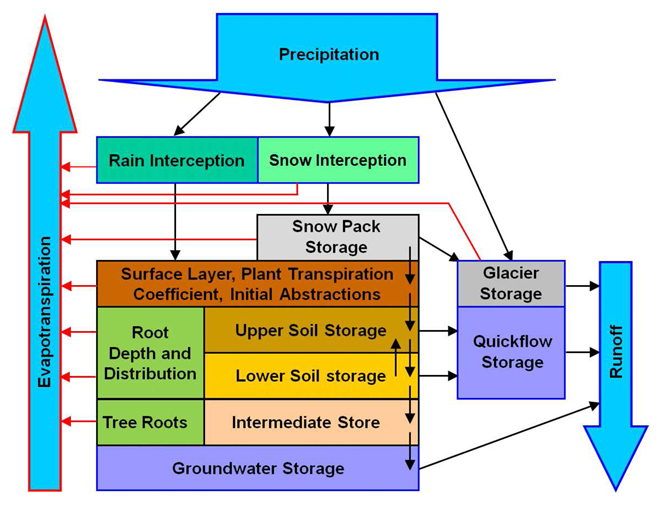
Figure 1: The ACRU agro-hydrological modelling system